►FEATURES
√ Beautiful and detailed Hardware/GPU accelerated vector charts (text stays upright on rotation)
√ Long press to query the details of Marine object (Buoy, Lights, Obstruction etc).
√ Customizable depth(Ft/Fathom/Meter) and distance units (km/mi/NM)
√ Customizable Shallow Depth.
√ Record tracks, Autofollow with real-time track overlay & predicted path vector.
√ Voice Prompts for marine navigation (requires GPS )
√ 1ft / 3ft depth contour maps for anglers for selected lake maps.
√ Supports GPX/KML for boating route editing/import.
√ Tide & Currents prediction.
√ Seamless chart quilting of marine charts
√ Enter or import Waypoints.
► MAPS
The maps include coverage of Germany (both coastal and inland waters) (derived from BSH data).
► Advanced NMEA Instrumentation
√AIS over TCP/UDP
√Wind speed, direction, temperature, depth, GPS over NMEA
►ROUTE MANAGEMENT / TRIP PLANNING
√ Create New Route/Edit Existing Routes
√ Move Points
√ Add points to an existing route leg
√ Delete / Rename points
√ Import GPX, KML & KMZ files
√ Plot/Edit Routes
√ Enter Waypoints
√ Share/Export Routes, Tracks & Markers
√ Reverse Routes
►GPS FEATURES
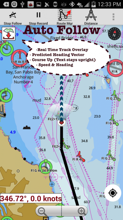
√ Auto Follow
* Real Time Track Overlay
* Predicted Path Vector
* Course Up (Text stays upright)
* Speed & Heading
√ Route Assistance With Voice Prompts
* Prompts when approaching a boating route marker
* Continous distance and ETA updates
* Alerts when sailing/boating off route
* Alerts when boating in wrong direction
√ Record Tracks
►TIDE & CURRENTS
* For US, Canada, UK, Germany & New Zealand
* High/Low Tides
* Tidal Current Prediction
* Active Current Stations
► SHARING
* Share tracks/routes/markers on Facebook & Twitter
* Export tracks/routes/markers as compressed GPX files.
Sample Nautical Charts (please visit http://gpsnauticalcharts.com/main/de-nautical-charts-by-folio.html)
►Dysentery
►Berlin-Spandau navigation canal
►Spree-Oder Waterway
►Rhine-Herne Canal
►Wesel-Datteln Canal
►Elbe-Havel Canal
►Lower Havel Waterway (Spandau - Plaue)
►Saar
►Dortmund-Ems Canal
►Elbe Lateral Canal
►Weser
►Rhine-Main-Danube Canal
►Havel-Oder Waterway
►West Or
►Neckar
►Danube
►Moselle
►Mittellandkanal
►Main
►North Sea
►Rhine
►Elbe
►Baltic Sea
We do not host i-Boating:Germany Marine Maps on our servers. We did not scan it for viruses, adware, spyware or other type of malware. This app is hosted by Google and passed their terms and conditions to be listed there. We recommend caution when installing it.
The Google Play link for i-Boating:Germany Marine Maps is provided to you by apps112.com without any warranties, representations or guarantees of any kind, so access it at your own risk.
If you have questions regarding this particular app contact the publisher directly. For questions about the functionalities of apps112.com contact us.

|
| ||||
| Downloads: 8 | ||||
| Updated At: 2024-04-19 21:04:59 | ||||
| Publisher: Gps Nautical Charts | ||||
| Operating System: Android | ||||
| License Type: Free Trial |